Hackney has a lovely little museum. It’s housed in the modern library building beside the town hall. Despite its small size, they’ve managed to capture the history and spirit of the area. The focus is on immigration to Hackney and its oldest exhibit is from Saxon Times – it’s a logboat believed to have been made from a tree felled in 950 to 1000 when the tree was 200-250 years old. It was found near the Lea River in 1987. If such things fascinate you, you can read about it here. You’ll also see photos since my own were hindered by too much glare. The logboat itself is under glass in the floor but there is usually a model of it on the floor – it’s been stored away for now.
Of course the museum has been closed for some time but opened mid October with an exhibit of photos taken in the 1980s. I booked my slot online and waited for the day to arrive. Then on that day, I planned my route over there so that I could make the most of the time outside.
My walk started with a walk past these two ‘ladies.’ Ming Hai, a rather terrible Chinese restaurant and Casablanca, a Caribbean restaurant. I’d say both are worth a miss for food but they are constants around here. Ming was closed for some time and just reopened a week or so ago. Every day the owner comes out at the same time to open the shutters and set up her day. Her customers are loyal. Casablanca seems to be open for long, long hours – from early until quite late. People come from far away and we have our theories about its role in the community, based on who comes, who goes, and who hangs around outside.
Ming Hai and Casablanca
At the junction of Dalston Lane there’s Navarino Mansions. They were built in 1904 by the Four Per Cent Dwellings Company (now IDS, Industrial Dwellings Society) a group of Jewish philanthropists to relieve the overcrowding in homes in the East End of London. I love these buildings and they definitely deserve a lot more photographs and research but for now here are three images.
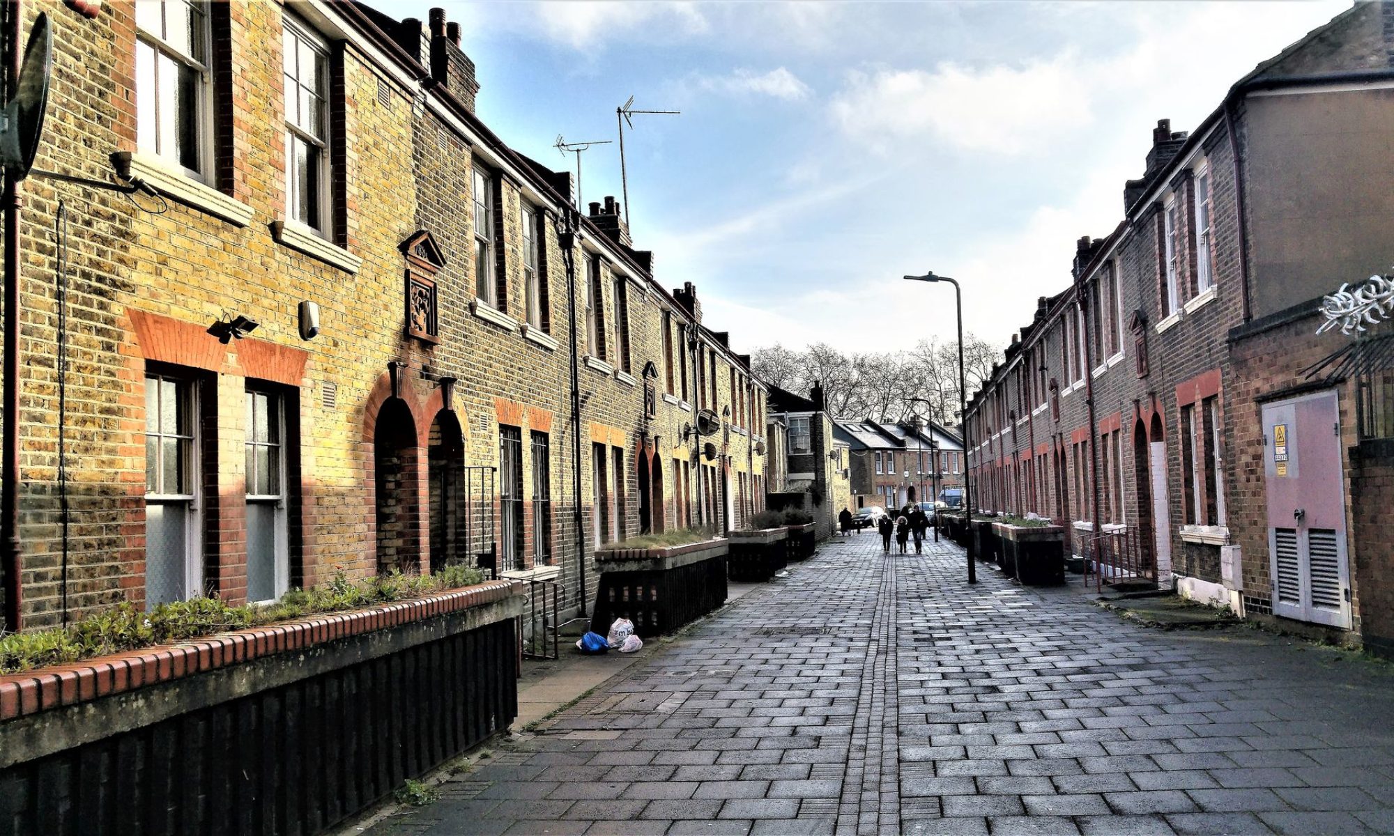
Navarino Road is an elegant street and quite different in character than how I started on Wayland Avenue (Navarino Road beginning on the other side of Dalston Lane). I can imagine that this street was settled by people who had a bit more money in their pocket.
Navarino Road housesOn the other side of Graham Road, Navarino Road looks autumnal and spacious
I always turn down Wilton Way. I love the villagey feel of that street. To my right a bit is Violet, the bakery which baked the cake for the royal wedding of Harry and Meghan. I’ve been going to Violet since I moved to Hackney. and Claire its American owner was an unknown. Claire lives on Wilton Way still but I don’t know where exactly. Today I turned left instead to head towards the back of the Hackney Empire and eventually the library.
The charming part of WIlton WayThe stark contrast of the estate on Witon Way when you get closer to Mare Street
After Wilton Way’s residential area there’s a pretty dramatic fork in the road, with one side (to the left) called Penpoll Road, a colourful but mysterious name.
Wlton Way meets Penpoll Road, a fork with a mysterious name
This morning I went to a pop up arts and crafts show in Dalston. ( I bought nothing but enjoyed the outing, and it gave me a chance to take a few photos to add to those I’d been saving for this blog.)
I’ve been feeling deflated recently. Too many apocalyptic thoughts. Sitting here waiting for the infections to rise and the death toll to start climbing, how else can anyone feel? Well, many don’t feel that way at all, so I’m told.
It’s easy to feel sorry for myself and my lethargy was getting me down. Going out helps me think about something else and it also helps me gain perspective.
Overall I’m an optimist. Although I’ll confess to being vastly disappointed and dissatisfied about the many things that others find great joy in, hope is always top or nearly top of my mind. I have great hope for many, many things. So think ‘silver lining,’ ‘counting my blessings,’ ‘it could be worse,’ ‘it will all work out in the end,’ and so on, and you have me in an optimistic nutshell.
I could be living in this makeshift shelter but I’m notAll of these shuttered shops could be out of business but they’re notI’m in a minority group, I’m a woman and I’ve faced adversity, but basically I’m hugely privileged – a white first-world childAnd even the wait or the first bus is shorter than many have to endure and gives me time to chat to a friend online, or whatever I choose to do, in a safe environment
It’s just three stops up to Dalston Junction – not far. It gives me a chance to look at the big picture and reflect on the back streets we walked on a few weeks ago. Dalston’s main streets at this point are Dalston Lane and Kingsland Road (Kingsland High Street).
Kingsland Road was part of the Roman route north named Ermine Street and was the Great North Road or Ware Road. In the early 1700s it was a toll road. Back then East of Kingsland Road was clay pits, brickfields, market gardens and nurseries. To the west it was arable land and dairy farms Despite being impoverished as the century went on, its proximity to the City made it popular , and by 1800 houses had gone up one by one along most of Kingsland Road, through Hoxton and Haggerston, towards the small hamlet of Dalston. Not so small anymore.
Today it’s a very busy high street and, since we moved into the area, it’s become trendy even before the regeneration started. What struck me today was how mixed the architecture and state of housing was in this area. When the ‘luxury flats’ sprang up, we’d often wonder who the tenants were that were happy to pay huge sums of money, and to look down on what’s sometimes squalid and wait for better times ahead.
The name Dalston is thought to come from Deorlaf’s tun (farm), in much the same way as nearby Hoxton was named after the farm of ‘Hoch’. The village was one of four small villages within the Parish of Hackney (along with Newington, Shacklewell, and Kingsland) together having only as many houses as the village of Hackney. Around 1280 a leper hospital was founded here but by the 18th and 19th Centuries the area had changed from being agricultural and rural to urban. By 1849, it was considered suburban, with some handsome old houses. By 1859 the railways came in and the village disappeared.
This corner where Kingsland Road meets Dalston Lane is original but Sheer Bliss, a hair salon which has been there for a long time, has recently had a facelift. It’s competing with some very modern shops and salons now. I can’t read the engraving on the corner but the building is Edwardian and may have been a cinema and then a bankStanding on Kingsland Road, my back to Dalston Junction station and facing Dalston Kingsland Station, the contrast is starkAnd from the back streets, the contrast is even more markedThe modern Dalston bus station, the back of the flats at Dalston Square, and the hanger-on Kingsland Road houses. Comfy together
Time to move off the main road, over behind the Kingsland Road and Dalston Lane junction.
Arcola Theatre, the old Reeves building
Beyond the Arcola Theatre is Abbot Street, basically a laneway leading down to a back yard. It’s a bit scary to walk down when it’s not daylight but, if you continue, you’ll hit the yard and find The Dusty Knuckle Bakery and the 40ft Brewery. The Dusty Knuckle has been here a while now. It’s a social enterprise that trains young offenders, and supplies some of London’s most renowned chefs with bread and pastries. They’re renowned for their inventive sandwich combinations, like Isle of Wight tomatoes, smoked anchovies, almond aioli, lovage, garden lettuce. or Chargrilled hispi cabbage & fennel, crispy pink fir potatoes and romesco. Their pizza is pretty good too! The Dusty Knuckle also has a school, where I learned fermentation and also how to make sour dough rye bread.
The 40ft Brewery is the Dusty Knuckle’s neighbour inside the yard. This makes for some great collaborations. When in the DK classes there was always plenty of free 40ft beer in the fridge while we worked. (I always took mine home for another day.) The independent home brewing company opened in 2015 and had just two 20 foot shipping containers. They’ve since expanded to 150 feet, have a bustling beer garden, and the original name has stuck.
Walking down Abbot Street to the back yard
This lovely door in the shabby alley of Abbot Street
Off the Abbot Street Yard. Such scenes always capture me40ft Brewery Seating in Abbot Street YardDusty Knuckle Bakery pizza ovenAt the back of the newer buildings along Kingsland Road, Arcola Theatre on the leftAshwin Street, Dalston. It’s like a hidden back street with lots of treats. The Arcola Theatre, Cafe Oto, and the lovely Print HouseThe old Reeves Artists Colour Works, now the Arcola Theatre building
The Reeves building dates from 1868. William Reeves was apprenticed as a gold-and-silver wire-drawer. He set up in business as a colourman in or before 1766 and in 1768 he partnered with his older brother, Thomas Reeves. They were awarded the Silver Palette of the Society of Arts, for the invention of the watercolour cake. They started in Little Britain (St Bartholomews) advertising as ‘Superfine Colour Makers.’ 1868 In London City Press of January 18th 1868 E.H Horne was announced as architect of a new Reeves factory building, with Sewell and Sons as builders – their tender was for £2,343. The brand survives today, passed from father to son, and it’s the brand of painting box that sits on my shelf here. It’s good to know a bit about the brand now.
A close up of the roof at ReevesGlorious facade of Reeves, now The Print House. It houses offices and studios and has a lovely rooftop with views over Dalston and a bar and a stageIf this door could talk…I’ve yet to find the building’s history or date of constructionDalston Eastern Curve Garden -tarted up – with a queue for its later opening, nicely distancedAcross from the Curve Garden, the new Dalston Library and Hackney Archives on Dalston Lane. Notice the Halloween balloons
We wandered around the back streets further down Dalston Lane. There are a lot of modern buildings back here and some really nice renovated buildings too. For some very odd reasons I took hardly any photos. Where are they? The loft building, Springfield House Lofts, made me a little envious but no balconies so I’ll give it a pass. As if I could even afford a bedsit in there! (Sorry -studio, or bachelor apartment, if you prefer.)
I learned that Springfield House, formerly the Shannon Factory, is the largest surviving building designed by the “remarkable” Edwin Otho Sachs – a man so passionate about fire prevention he spent time working with fire brigades in Berlin and Paris to learn more about how blazes spread. The Shannon Factory (opened in 1902) made office and bank furniture and used many combustible products. Sachs was their man.
It’s still a lovely building. Krish tells me the rest of the factory complex is still there but I recall it only by looking at Google Maps to see that the whole factory is there but part of it is gated. Another revisit for sure!
New build on the left, repurposed Springfield House Lofts on the right – Tyssen StreetDalston Cross, where Dalston Lane meets Graham Road before continuing down towards Hackney Downs Station. It’s not hard to imagine when Dalston was a hamlet. That’s another walkAt Dalston Cross, what looks like an old church or rectory building. I always admire it. I need to look longer and closer some time to get a clue what it once was
I’m not sure if I’m excited or scared about the amount of ground and history I couldn’t cover but this was what I saw during a couple of hours on the back streets of Dalston.
In ‘normal’ times every now and again we would go to Canary Wharf to get our Toronto fix. It has that Toronto look and no wonder. Its earliest buildings were built by the Canadian company Olympia & York. There are even street names and apartment and shopping complex with Canadian influences. Everything is very modern and there’s even an underground shopping concourse. But we haven’t been for a very long time.
We had an idea that the weekends would be very quiet in the area and we’d be able to walk around and look at the river. And so we jumped on the 277 bus that takes us from Hackney Town Hall all the way to Canary Wharf DLR station.
Victoria Park Village from the bus. A more detailed look is on my Must Walk list
On the way, we pass through Victoria Park Village, Victoria Park itself, and Mile End. Victoria Park was my closest childhood park. I loved the playground there and also the pond. My grandfather would take me fishing at that pond. We’d buy maggots and mealworms in a little shop along the Roman Road and off we’d go. On the way down to the docks (where Canary Wharf is built) we pass by my old childhood home of (the now demolished) Lessada Street, just off Roman Road, and then down under the railway bridge where where the First Flying Bomb fell on London on 13 June 1944. It’s also where I saw a strange and scary site when I was about three years old.
I was walking with my dad – I loved those walks – and saw a fire under the bridge. There was a man and a motorcycle lying there in the hollow and they were alight. I asked my dad about it and he told me it was a guy (for Guy Fawkes Day) and hurried me on. When I was 14, I told my mum what I remembered and that I was sure it was a motorcycle fatality. She looked a little white and then confirmed it. She told me that my dad had hoped I would forget and never to tell me. He had been very shaken. She then asked me never to tell him that I knew. I kept my promise.
I didn’t take photos after Victoria Park. Photos from the bus are never very satisfying but it does mean there’s a gap.
Further down the road, we ride along Burdett Road. Here I have memories of visiting my great aunts – my mum’s mum’s sisters – in their tall, grand houses, or so they seemed in those days. And I remember the little Jewish grocer where they had barrels of olives, herring, pickled cucumbers – with a name something like Vlit Vlosh…who knows. And on down to Poplar, past the canal, and you see the river bank.
Except today there were dozens of people. At our stop, we noticed the same. Lots of people. We’d be wrong in our guess that it would be dead down there. They obviously all had the same idea that we had, to be somewhere ‘quiet.’ Oh well, nothing to do but carry on and see whatever we could.
The main financial district of London is in The City, the original square mile. Canary Wharf is the secondary business district. It’s on the Isle of Dogs and is named after one of the quays of this dockland area, No. 32 berth, where fruit was unloaded from the Canary Islands. And that’s why it’s called the Isle of Dogs. The Canary islands gets its name from the large dogs found there by the Spanish (Canarias from Canine). Canary Wharf is just one piece of the Docklands area and it has many tall buildings, including what was once the tallest (now third tallest) in the UK, One Canada Square, with its iconic pointed roof. Docklands was once just that, a large area of docks on the River Thames. As a child, I learned it was an area that was to be avoided, and also the place where the majority of bombs were aimed during the second world war. East India Docks, West India Docks – dangerous and dirty or not, it all sounded very exotic to me.
These once dangerous, dirty docks are now sparkling and modern roads, full of gleaming office towers and quayside cocktail bars. For years it was like a secret part of London known only to bankers and the like, but based on the number of people we saw here, I’d say the secret is out.
Canary Wharf DLR stationQuayside
And sometimes you get reminders you are on the Thames
Wandering around the Canary Wharf jungle!
Amidst the towers, an oasis of green, Jubilee Park
Crossing the South Dock bridge here we found a little food truck areaFrom over here, we could see the O2 ArenaIn the underground concourse on our way to Waitrose. Doesn’t it look like Toronto?
The floors are filled with tiles showing the history of the area
We’d outstayed our two window for getting home again, so home we came. Meanwhile, I found a good interactive map of the Canary Wharf area at https://canarywharfmap.com/ if you’d like to have an overview.
Every year I go for a check up at the Sleep Clinic at St Bartholomew’s Hospital in East Central London. This year my annual check up was by phone but, on that call, they told me that they wanted me to come in and have a face-to-face appointment with a therapist to get a new machine and mask. In fact, I was welcome to send a representative but that would mean not choosing a mask myself. I decided to go in person.
I have to say that I was a little nervous about going – it was the farthest I’d travelled in months, and it was to a hospital. However, I thought I could make the best of it by taking photographs in the area. My wish list was Smithfield Market, which is under development for the Museum of London, the hospital itself, and a quick visit to Three Uncles Cantonese barbecue take out, on my way to the train. Krish thought he might come and wanted to see Charterhouse Square. I wasn’t sure he’d be coming until I was almost ready to leave on Thursday late morning. Yes, he was!
From Home to Barts, four miles away
There are several ways to reach Barts, which is what most people call St Bartholomew’s Hospital, but we opted to take the bus which usually goes all the way to the door or to Barbican tube station, which is at the east end of the large area that Barts and Smithfield covers. Our bus was going only as far as St Pauls so Barbican it was.
It would be tough to find another area of London with more and varied important history. Another bout of research reveals so many dates and occasions, my head swims, but I tried really hard to stick to my route and focus! To be honest, all the buildings, plaques, and monuments were going to be more than enough to keep the anxiety at a reasonable level.
A rough guess at my exploration routeApproaching the Angel Area before turning down towards Goswell Road, which leads into The City. So far, so quietLeaving Angel, with the Barbican estate loomingCrescent House on Goswell Road, my photo bleached by sunlight. It’s my landmark to start getting off the busSome of the towers of The Barbican estate
Two estates are dominant at Barbican – Barbican estate itself and the 1950s Golden Lane Estate. Golden Lane Estate comes first. (This from my brother: ‘The first building to be completed was Bowater House, off Fann Street, named for a Lord Mayor of London whose descendants we are related to.’) The most obvious building on the estate is Crescent House, which has a Tudor look so is very distinctive. The estate was built to house those who were bombed out during WWII. Crescent House was the last to be built. By then the huge Barbican scheme was already underway.
The Barbican estate deserves a blog of its own but I have no idea when that day will come. It’s a very complex site over a very large area. Barbican covers the area that was once the main Roman Fort of London (120 AD) – barbican , from Barbecana, which means a fortified outpost or gateway. It has 2,000 flats, maisonettes, and houses on what was a bombsite after WWII. While Golden Lane estate is a City-owned council estate, Barbican is an upmarket development, designed and built for affluent City professionals and their families, charging market value rents.
‘City Jam’ (Eley Kishimoto 2018) pedestrian cossing by the Barbican, part of the Culture Mile ‘Colourful Crossings’ art project
If you go to Barbican estate, you’d be impressed at its size (15ha) and variety of use. It contains the Barbican Centre (an arts, drama and business venue), the Barbican public library, the City of London School for Girls, the Museum of London, and the Guildhall School of Music and Drama. There are gardens, cafes, even arenas in there. What you’d also notice is the walkways, called ‘highwalks’ one to three stories above ground level. This separates the estate from the car parks and roads below. You can get lost walking about the highwalks – very entertaining. I wasn’t even going to try going in – it demands a lot of time!
Leaving the Barbican towers behind, cross the road and you’ll find Long Lane, which leads into the medieval area of Bartholomews. I love wandering around here, although today not everything is open. I could take a hundred photos here but today it’s just a handful.
Founders Hall, built in 1985 in the traditional style. The original (1531) was destroyed in The Great Fire. This building is the fifth Founders Hall. Founders? An early medieval guild formed to promote the interests of its members and to ensure high standards of quality and workmanship in articles of bronze and brass
The Priory Church of St Bartholomew the Great, a medieval church founded in 112341-42 Cloth Fair, Barbican. Built between 1597 and 1614, its the only house in the City of London to have survived the ‘Great Fire’ of 1666. This makes it the oldest habitable home in the city. I admit to cheating on this – I didn’t photograph it! How I missed doing so, I have no idea
Rising Sun pub, its alley leading to a view of Smithfield Market
Every now and again I take a walk down Hackney Road. It was on my list of places to revisit and Krish suggested adding in Columbia Road on a non-market day. Add to that my increasing ‘need’ for Vietnamese food and we had a deal.
Home at the top and the areas I visited at the bottom of the mapMy route along Hackney Road and Columbia Road. It was slightly twistier than this but it’s close enough. It felt like a long way
The days are shorter and the temperature is staying in the 17 to 20C range. It suits me well. Any warmer than 23 and I’m not so happy being out for long walking. There’s an added layer to being out these days. The kids have gone back to school. In the mornings and around 3:30, the buses and roads get much busier. I’ve read that they are suggesting as many students as possible ride bikes or walk to school and stay off public transport. While this must be happening, it’s also true that car traffic has increased. There must be a lot of parents driving students to school and, at peak times, there’s a lot of stop and go traffic outside the window.
At any rate, added to the ‘Covid caveats’ of avoid the post office on a Friday and Monday, stay away from the supermarket on the weekend, don’t walk on the Narrow Way unless you have no choice, I’m adding don’t travel on the buses till after 10am or between 3:15 to 4pm.
Look how many buses on Dalston Lane by The Pembury! This is almost as bad as it usually gets on Oxford Street. They increased the number of buses for the returning students
We missed most of the buses but then one showed up and we got in as far as Cambridge Heath Station. That’s where Hackney Road begins. Hackney Road is thought to follow a prehistoric route and into the 1700s was farmland with very few homes. During the 19th century this changed dramatically, as commercialisation became more the norm, and it took on a very urban look.
Before we set out we explored Clare Street, which runs along the Cambridge Heath railway arches. We had a little chat with some guys in the motorcycle shop. They reported business was quiet.
Top of Hackney RoadMotorcycle shop under the arches at Clare Street
There’s always a lot of art on Clare Street but I don’t think there’s been anything new since I was last there
We took a little walk back towards Hackney Road again passing new and old buildings and some which seemed a mix.
This building looked like they’d built modern stories on top of the original houseThe old-new building turned out to be the ex Duke of Cambridge. Krish pointed out that was at Cambridge Heath and that was how it was named
The last time we went down Hackney Road, we hadn’t enjoyed it as much as usual so this time we wandered slightly off the road and looked at what was around the corners. There were some cool discoveries along the way.
This has been a hotel for a while and now it’s a Mama Shelter. This chain calls itself an urban refuge – lively, unique and quirky There are hotels in 12 cities and 7 countriesColourful houses on Pritchard’s Road, and the east end hold-out, Billy’s CafeOld council flats on Coate Street. The balconies seemed randomLovely old Charrington’s Pub on Coate Street. Around here there would have been pubs on almost every corner
We also came across two very interesting buildings as we turned back to Hackney Road. On the corner with Garnet Street is the former Adelphi Chapel School date “1853, enlarged 1868”. This was a missionary school with 30 pupils built as a day and Sunday school, but also used as a chapel. And then we saw a baby blue building and couldn’t decide if it was cool or just ugly. It turned out to be a significant building. Built for £300,000 in 2002, FAT’s Blue House is a live-work house with an over-emphasised street-facing façade. The practice considers it to be one of the most important houses of the 21st century, or so the FAT website says.
Adelphi Chapel School buildingFAT Blue House
The plan to divert occasionally was working out really well, but we were back on the main road and headed towards Columbia Road. At Goldsmith’s Row, there are two more treasures. First the old Queen Elizabeth Children’s Hospital. Also known as the North-Eastern Hospital for Sick Children, it was founded in 1867 and admitted 10,000 patients each year. For years we would walk past this then-derelict building. It was large and sombre. Then one day we noticed it was going to be developed into new flats. I seem to remember feeling a bit crestfallen that the blackened historical building would be gone. It’s not so bad, though.
It’s called Mettle & Poise, and was a sell-out success, with every new home sold off plan two years before the completion of the redevelopment in 2017.
On the other side from the old hospital (now M&P) is the lovely wooded Hackney City Farm. It was established in 1984 as a community and educational resource and to give borough residents, particularly young people, experience of animals. There’s a farmyard, area for grazing, garden and a tree nursery with butterfly house. The farm is home to a range of animals, including poultry, sheep, rabbits, bees, pigs and a donkey. Hackney City Farm also runs workshops and sells honey and free range eggs, among other things. A city oasis.
Hackney City Farm. The animal yards are closed for now but the cafe and shop are open for business
As you can probably tell, this is another area of Hackney (bordering on Tower Hamlets) that was overwhelming to read about. I’ve done my best!
There was one more stop for us before we found Columbia Road – the Phlegm mural on the Portuguese Love Affair cafe.
The Phlegm wall art in Ion Square on the Portuguese Love Affair Cafe building